Image by the author.
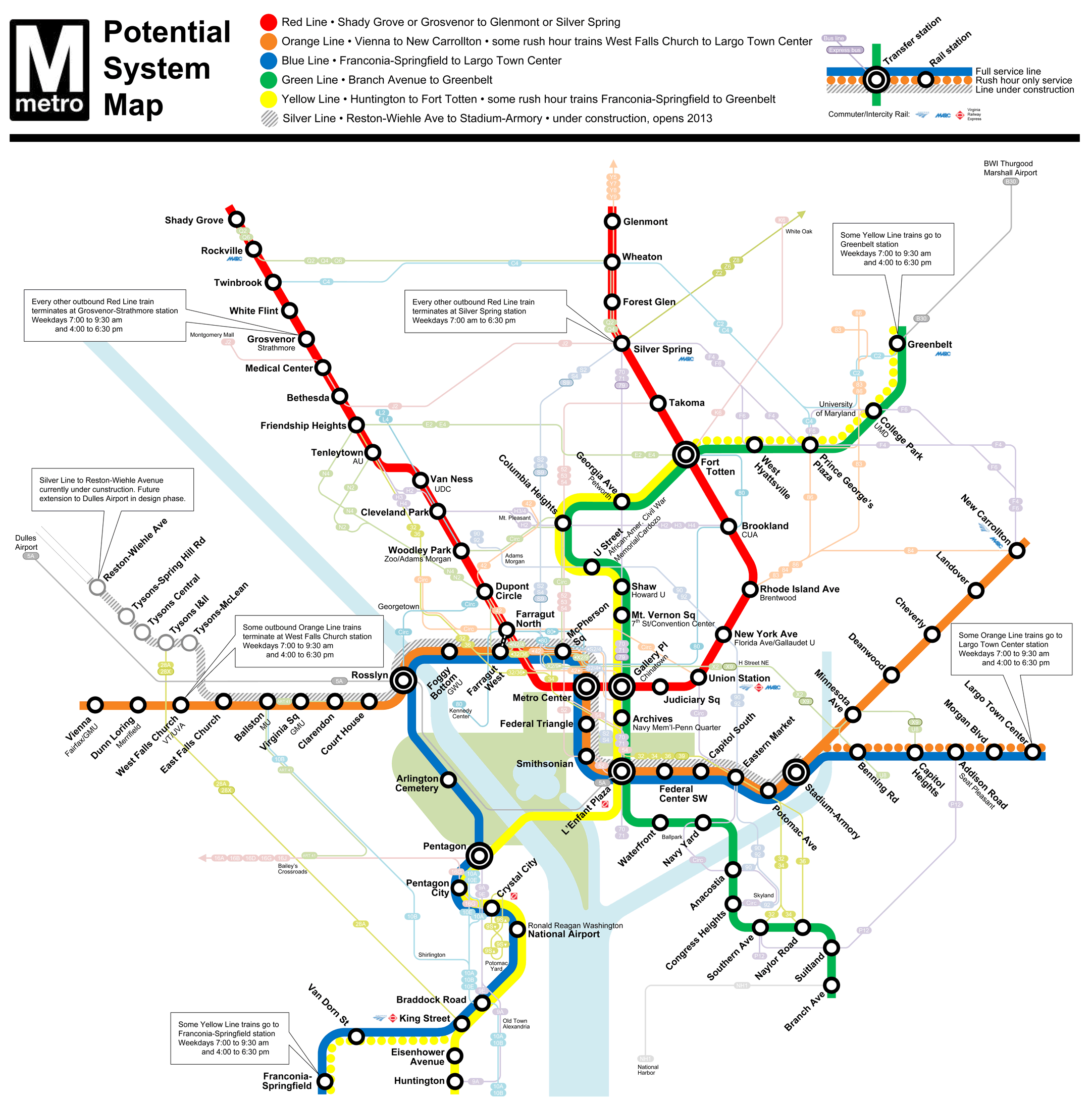
A future version of the Metro rail map could show buses as well, based on a recommendation from the recent Bus Transformation Project report. This would follow a practice already in use in Boston and an idea I proposed in a 2011 contest to redesign the Metro Map (the map above).
Regional leaders and governments participated in the Bus Transformation Project, funded but not controlled by WMATA. Most of the recommendations involved actual bus service and fares, but the map was among them. Here are the ten ideas from the study the WMATA board chose to set as “priority recommendations”:
- Recommendation A: Update WMATA’s Metrobus service guidelines;
- Recommendation C: Draft relevant policies such as Metrobus service standards and future potential recommended changes to Metrobus service definitions;
- Recommendation D: Study the restructuring of the Metrobus network to create an efficient and customer-focused network;
- Recommendation F: Support implementation of bus priority projects such as bus-only lanes and bus rapid transit (BRT) within WMATA’s role as a service provider and facilitate the study of bus priority projects by lending expertise to Jurisdictions and Responsible Parties actively implementing and funding such projects;
- Recommendation K: Incorporate major Metrobus and regional provider bus routes in the Metrorail System Map wherever displayed.
- Recommendation M: Provide free transfers between Metrobus and Metrorail and local bus service providers where supported by jurisdictions and within funding constraints;
- Recommendation N: Provide jurisdictionally funded fare buy down options for low-income riders; and
- Recommendation O: Create and implement a mobile app solution for Metrorail, Metrobus and local bus service provider customers to plan and pay for trips in one place;
- Recommendation P: Develop regional passes that work across all providers;
- Recommendation V: Test and evaluate zero emission, including electric buses to add to the bus fleet;
Bus lanes and free transfers (recommendations F and M) were riders’ top priorities according to a survey. Many more are also critical either to riders, to governments (in order to actually improve buses for riders), or the planet (to ensure riders continue to live).
A better map isn’t as critical as some, but helping people be more familiar with buses, by showing key routes which connect Metro stations or connect significant areas to the Metro, could help people know about and use the bus. It’s what Boston already does with its MBTA subway map:

Detail of subway map by MBTA.
In 2011, Metro needed to redesign the map to fit in the under-construction Silver Line. We teamed up with them to run a contest for ideas, and got 18 submissions. The voting system isn’t still online, but you can see them all at these nine roundup articles: 1, 2, 3, 4, 5, 6, 7, 8, 9.
Matt Johnson and I managed the contest. We both also entered anonymously; we didn’t tell readers or the jury that we’d entered, so nobody was biased. We didn’t win (designer and Transit Maps blogger Cameron Booth did), but both of us independently hit on the idea of condensing very long station names, like “Mount Vernon Sq/7th St-Convention Center” into a station name (“Mt. Vernon Sq”) and subtitle.
This was a strategy to deal with the name sprawl which had afflicted Metro. The agency really liked the idea and chose to implement it. (The Silver Line recorded announcements largely ignore the difference between station names and subtitles, so arguably Metro has backed off on really taking advantage of this.)
In my submission, I also tried including the bus lines, MBTA-style.
I said:
The Metro map puts places like Eastern Market, Wheaton and Crystal City “on the map” for many who wouldn’t otherwise know about them. But what about the other places that don’t have Metro, like Georgetown, H Street, Potomac Yard or the University of Maryland?
Drawing on Boston’s map, which now includes “key bus routes” that run at high frequency 7 days a week, I created a map that shows major bus routes. The routes depicted are those that run most often, using the “15 minute bus map” that Metro’s planning department created, plus a few local bus routes and other key connecting routes from the Priority Corridor Network.
The lines are fainter in order to avoid detracting from the Metrorail map, but they illuminate for riders where other non-Metro major sites are located, how to get there from Metro stations, or which routes connect other Metro stations at the outer edge of the region to each other.
Hopefully, including such information on the map will help people become much more cognizant of the existence of buses and less intimidated to give them a try.
Here’s what Matt wrote about the jury’s conclusions:
The jury liked the idea, but they were concerned about the execution. They felt that the bus lines were hard to read, and were curious as to how some lines were chosen and others were not (since we didn’t give them any information beyond the maps themselves). They also felt that adding bus lines to the map would mean WMATA would need to reprint the map every time a bus change occurred.
The Bus Transformation Action Plan Recommendation K has additional ideas beyond just the rail map. It calls for a “regionally consistent route numbering system; standardized easy-to-read system and route level maps; [and a] one-stop-shop for online and print route and system information.” Board members pushed the rail map idea specifically forward in their resolution.
"metro" - Google News
March 03, 2020 at 10:33PM
https://ift.tt/2IgMAfz
The Metro rail map may one day show bus routes - Greater Greater Washington
"metro" - Google News
https://ift.tt/37WGdtA
Shoes Man Tutorial
Pos News Update
Meme Update
Korean Entertainment News
Japan News Update
Bagikan Berita Ini


0 Response to "The Metro rail map may one day show bus routes - Greater Greater Washington"
Posting Komentar